Gravity method is a geophysical method used to determine subsurface conditions based on differences in the gravitational field in a certain area. The measurement of the gravitational field will provide information about a particular density of subsurface conditions. Based on this parameter, a geoscientist can interpret the subsurface structures or rock types of a certain area.
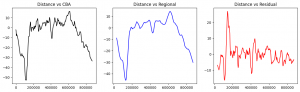 In general, the calculation results of gravity anomaly are divided into three types: CBA (Complete Bouguer Anomaly), regional, and residual anomalies. These results are differentiated based on their purpose and area coverage. The main workflows of this gravity data processing are as follows:
- Convert CBA measurements at each station to a CBA map
- Slice a particular line on the CBA map
- Analyze spectrum on the selected line using Fast Fourier Transform
- Regional & residual trend analysis
- Convert regional and residual slice into a map